Environmental information is an essential knowledge tool for citizens, political decision-makers and all stakeholders, both to overcome the logic of emergency, and to foster a culture of prevention that helps to increase awareness about the urgency of a rational, effective and efficient environmental policy.
The great attention given worldwide to urban areas confirms the far-sightedness of the choice made years ago to realize the Report on urban environment quality within the National System for Environmental Protection (SNPA). Since its first edition in 2004, the Report has always been a product of a consolidated and synergic collaboration between ISPRA and the Regional and Provincial Environmental Agencies (ARPA / APPA) . The establishment of the SNPA has given a further propulsive drive to the joint effort. Interaction with the environment today takes increasingly place mainly in the man-made areas of our territory. That’s why we need to orient the development towards sustainability starting from built environments.
Due to the density of population and production activities, the highest levels of pollution and pressure are concentrated in urban areas. At the same time, the urban dimension is crucial for experimenting in the large human settlements both the sustainability of development models on a global scale, and the policies relevant to the future of the planet and the quality of life of citizens.
In consideration of the key role that cities play in pursuing sustainable development, the European Union has introduced specific actions under the 7th Environmental Action Program (7EAP). Furthermore, the EU entrusted the European Commission with the identification of a set of criteria by 2020 to assess the environmental performance of cities, considering also the economic and social impacts. Sustainable development, in this perspective, is pursued by measuring the sustainability of cities through their environmental, social and economic components, considered as interdependent aspects of the same issue, to promote the health and well-being of all citizens. Therefore the production of qualified environmental information is necessary to represent the real environmental conditions of our cities.
The historical data relating to the urban environment are those describing the indicators presented annually in the Report on urban environment quality. They have been organized in a dedicated database (urban areas) with the aim of making available to the public an online environmental information tool. The database is continuously updated and an expansion of its contents is expected with the constant addition of new environmental issues.
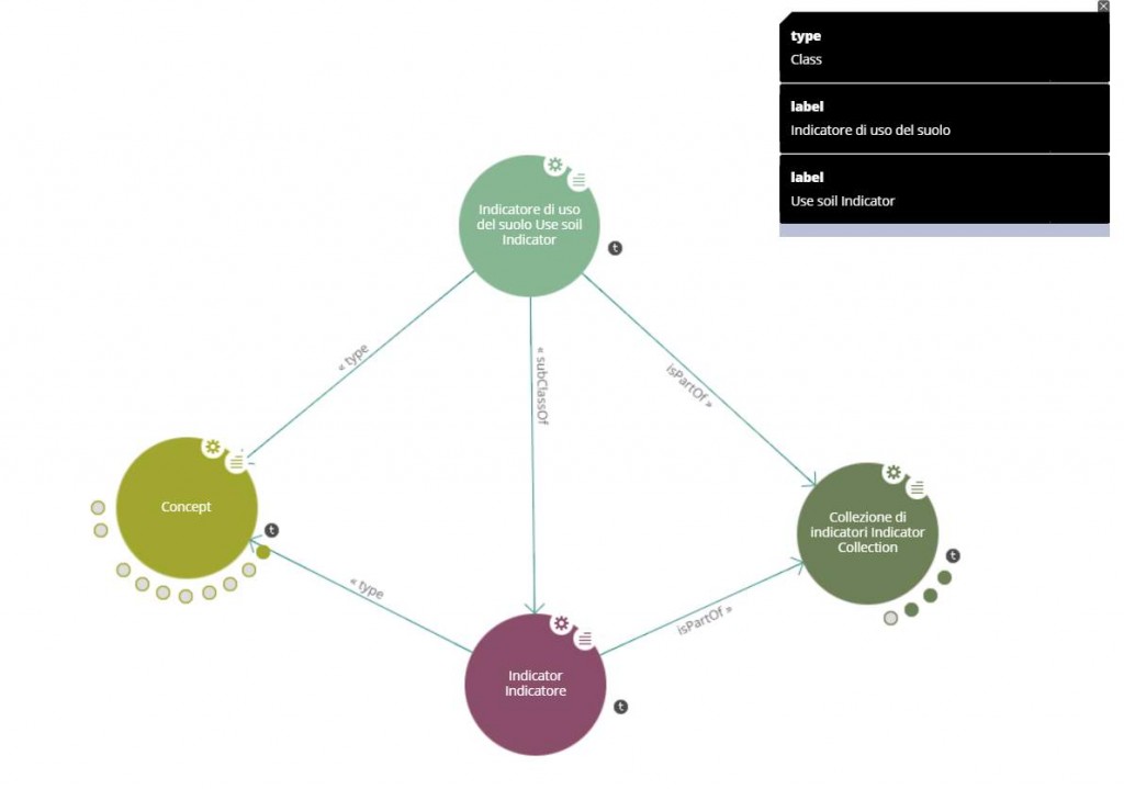
However, today the SNPA takes a step forward: the open data related to environmental quality in urban areas are also made available in the Linked Open Data (LOD) format, in line with the regulations regarding the collection, access, interoperability and sharing of the environmental data, as per Law 132/2016 and art. 23 of law n.135/2012.
This process aims at increasing the information made available, within an integrative synergy that will become part of the world of Information Communication Technology.
The nature of this technology allows to connect the Open Data already present in the database of urban areas, so that they can be part of a single informative, global and shared space, also providing the possibility to analyze data coming from multiple sources and to possibly correlate them with each other.
For further details:
Report on urban environment quality
Environmental quality in italian urban areas
WHAT DOES IT INCLUDE?
- For the provincial capital towns and for the densely populated cities that are not provincial capital a collection of urban environment quality indicators associated to the reference year
- Each particular indicator is defined by URI in the urban areas dataset
WHAT ALLOWS TO DO?
- The direct consultation of the single resource – for example a particular indicator referred to a given place and year – through access to its URI (persistent internet identifier)
- Expose the data to third-party applications through SPARQL REST API
- The direct download of the entire database (in triple RDF format)
- The access to the SPARQL Endpoint to perform any targeted query on the data
EXAMPLE OF QUERY
[execute query] – Urban Areas Indicators
PREFIX ispra-top: <https://w3id.org/italia/env/onto/top/>
PREFIX rdfs: <http://www.w3.org/2000/01/rdf-schema#>

SELECT DISTINCT str(?broaderlabel) AS ?theme ?parbroader AS ?URItheme str(?parlabel) AS ?parameter ?p AS ?URIparameter
WHERE
{
?p a ispra-top:Parameter;
  ispra-top:hasBroader ?parbroader;
  rdfs:label ?parlabel .
?parbroader   rdfs:label ?broaderlabel  .
FILTER (langMatches(lang(?parlabel),"en"))
FILTER (langMatches(lang(?broaderlabel),"en"))
FILTER(?dataset = "urban")
BIND(SUBSTR(str(?parbroader), 32, 5) AS ?dataset)
}
ORDER BY ?broaderlabel ?parlabel
[execute query] – For which cities and years is the value of the used agricultural surface available?
PREFIX ispra-top: <https://w3id.org/italia/env/onto/top/>
PREFIX rdfs: <http://www.w3.org/2000/01/rdf-schema#>

SELECT DISTINCT CONCAT(?splacetype, "-",  str(?placelabel)) AS ?location  str(?broaderlabel) AS ?theme str(?parlabel) AS ?indicator ?indicator_ AS ?URIindicator ?syy AS ?year

WHERE
{

## REPLACE "Utilised Agricultural Area" with the indicator of interest (e.g. "total of registered EMAS sites")

##For which cities and years is the value of the used agricultural surface available?
FILTER(str(?parlabel) = "Utilized Agricultural Area")

##For which provinces and years is the number of EU Ecolabel licenses available?
#FILTER(str(?parlabel) = "EU Ecolabel awarded licenses/products-services")

##For which cities and years is the number of registered EMAS sites available?
#FILTER(str(?parlabel) = "total of registered EMAS sites")

##For which cities and years is the number of road accidents available?
#FILTER(str(?parlabel) = "traffic accidents")

##For which cities and years is available the number of road accidents with the involvement of weak road users?
#FILTER(str(?parlabel) = "weak members of the road (dead + injured)")

##For which cities and years are available data on the availability of public green per capita
#FILTER(str(?parlabel) = "per capita availability of public green")

##For which municipalities and years are available the values of seats-km offered by local public transport buses
#FILTER(str(?parlabel) = "Seat-km offer by bus (million)")

##For which cities and years are available data on the number of cars registered to private individuals?
#FILTER(str(?parlabel) = "passenger cars (private)")

##For which cities and years are available data on the number of cars with a Euro 0 emission standard registered to private individuals?
#FILTER(str(?parlabel) = "euro 0 passenger cars (private)")

##For which cities and years are available data on the movement of goods in the ports present in the database?
#FILTER(str(?parlabel) = "Total tonnage (t)")

##For which cities and years are data on separate collection available
#FILTER(str(?parlabel) = "separate collection rate")

##For which cities and years are available data on the rate of tourist accommodation (beds for every 100,000 inhabitants?)
#FILTER(str(?parlabel) = "hotel beds")

?p a ispra-top:Parameter;
  ispra-top:hasBroader ?parbroader;
  rdfs:label ?parlabel .
?parbroader   rdfs:label ?broaderlabel  .
?icc ispra-top:isParametrisedBy ?p;
  ispra-top:isPartOf ?ic .
?indicator_  ispra-top:isMemberOf ?icc;
  ispra-top:atTime ?yy;
  ispra-top:hasValue ?vv.
?ic ispra-top:isPartOf ?c.
?c ispra-top:isPartOf <https://w3id.org/italia/env/ld/urban/dataset> ;
  ispra-top:isCollectionOf ?place.
?place  rdfs:label ?placelabel;
  a ?placetype .
FILTER (langMatches(lang(?parlabel),"en"))
FILTER (langMatches(lang(?broaderlabel),"en"))
FILTER(IF(?splacetype = "Municipality", langMatches(lang(?placelabel), "it"),"xxx"))
FILTER(?dataset = "urban")
BIND(SUBSTR(str(?parbroader), 32, 5) AS ?dataset)
BIND(SUBSTR(str(?placetype ), 40) AS ?splacetype)
BIND(SUBSTR(str(?yy), 44) AS ?syy)
}
ORDER BY ?splacetype ?placelabel ?syy
[execute query] – How many weak road users are dead and injured as a result of road accidents in the municipalities in 2018?
PREFIX ispra-top: <https://w3id.org/italia/env/onto/top/>
PREFIX rdfs: <http://www.w3.org/2000/01/rdf-schema#>

SELECT DISTINCT ?syy AS ?year CONCAT(?splacetype, "-",  str(?placelabel)) AS ?location  str(?parlabel) AS ?indicator str(?value_) AS ?value (str(?umdesc) AS ?unitodmeasure)
WHERE
{

## REPLACE "passenger cars (private)" with the indicator of interest (e.g. "total of registered EMAS sites") and the year of interest

##What is the value of the used agricultural surface in the Municipalities in 2010?
#FILTER(str(?parlabel) = "Utilized Agricultural Area")
#FILTER(?splacetype = "Municipality")
#FILTER(?syy = "2010")

##What’s the number of EU Ecolabel licenses in the Italian provinces in 2017?
#FILTER(str(?parlabel) = "EU Ecolabel awarded licenses/products-services")
#FILTER(?splacetype = "Province")
#FILTER(?syy = "2017")

##) What’s the number of EMAS registered sites in the Municipalities in 2019?
#FILTER(str(?parlabel) = "total of registered EMAS sites")
#FILTER(?splacetype = "Municipality")
#FILTER(?syy = "2019")

##How many weak road users are dead and injured as a result of road accidents in the municipalities in 2018?
FILTER(str(?parlabel) = "weak members of the road (dead + injured)")
FILTER(?splacetype = "Municipality")
FILTER(?syy = "2018")

##How many goods are moved in the ports whose district falls within the urban areas in 2018?
#FILTER(str(?parlabel) = "Total tonnage (t)")
#FILTER(?syy = "2018")

?p a ispra-top:Parameter;
  ispra-top:hasBroader ?parbroader;
  rdfs:label ?parlabel .
?parbroader   rdfs:label ?broaderlabel  .
?icc ispra-top:isParametrisedBy ?p;
  ispra-top:isPartOf ?ic .
?indicator_  ispra-top:isMemberOf ?icc;
  ispra-top:atTime ?yy;
  ispra-top:hasValue ?vv.

?vv ispra-top:value ?value_;
    ispra-top:hasUnitOfMeasure ?um.
?um rdfs:label ?umdesc .

?ic ispra-top:isPartOf ?c.
?c ispra-top:isPartOf <https://w3id.org/italia/env/ld/urban/dataset> ;
  ispra-top:isCollectionOf ?place.
?place  rdfs:label ?placelabel;
  a ?placetype .
FILTER (langMatches(lang(?parlabel),"en"))
FILTER (langMatches(lang(?broaderlabel),"en"))
FILTER (langMatches(lang(?umdesc), "en"))
FILTER(IF(?splacetype = "Municipality", langMatches(lang(?placelabel), "it"),"xxx"))
FILTER(?dataset = "urban")
BIND(SUBSTR(str(?parbroader), 32, 5) AS ?dataset)
BIND(SUBSTR(str(?placetype ), 40) AS ?splacetype)
BIND(SUBSTR(str(?yy), 44) AS ?syy)
}
ORDER BY ?splacetype ?placelabel ?syy
[execute query] – Which are the 10 Municipalities with the highest motorization rate (cars registered to private individuals per 1,000 inhabitants) in 2018?
PREFIX ispra-top: <https://w3id.org/italia/env/onto/top/>
PREFIX rdfs: <http://www.w3.org/2000/01/rdf-schema#>

SELECT DISTINCT ?syy AS ?year CONCAT(?splacetype, "-",  str(?placelabel)) AS ?location  str(?parlabel) AS ?indicator str(?value_) AS ?value (str(?umdesc) AS ?unitodmeasure)
WHERE
{

## REPLACE "passenger cars (private)" with the indicator of interest (e.g. "total of registered EMAS sites") and the year of interest

##Which are the 10 Municipalities with the highest number of road accidents in 2018?
#FILTER(str(?parlabel) = "traffic accidents")
#FILTER(?splacetype = "Municipality")
#FILTER(?syy = "2018")

##What are the 10 Municipalities with the highest availability of per capita public green in 2018?
#FILTER(str(?parlabel) = "per capita availability of public green")
#FILTER(?splacetype = "Municipality")
#FILTER(?syy = "2018")

##Which are the 10 Municipalities with the highest number of seats-km offered by buses in local public transport for 2018?
#FILTER(str(?parlabel) = "Seat-km offer by bus (million)")
#FILTER(?splacetype = "Municipality")
#FILTER(?syy = "2018")

##Which are the 10 Municipalities with the highest motorization rate (cars registered to private individuals per 1,000 inhabitants) in 2018?
FILTER(str(?parlabel) = "passenger cars (private)")
FILTER(?splacetype = "Municipality")
FILTER(?syy = "2018")

##What are the 10 Municipalities with the highest number of Euro 0 cars registered to private individuals in 2018?
#FILTER(str(?parlabel) = "euro 0 passenger cars (private)")
#FILTER(?splacetype = "Municipality")
#FILTER(?syy = "2018")

##Which are the first 10 Municipalities with the highest percentage of separate collection in 2018?
#FILTER(str(?parlabel) = "separate collection rate")
#FILTER(?splacetype = "Municipality")
#FILTER(?syy = "2018")

##Which are the 10 Municipalities with the highest tourist accommodation rate (total beds for every 100,000 inhabitants) in 2015?
#FILTER(str(?parlabel) = "hotel beds")
#FILTER(?splacetype = "Municipality")
#FILTER(?syy = "2015")

?p a ispra-top:Parameter;
  ispra-top:hasBroader ?parbroader;
  rdfs:label ?parlabel .
?parbroader   rdfs:label ?broaderlabel  .
?icc ispra-top:isParametrisedBy ?p;
  ispra-top:isPartOf ?ic .
?indicator_  ispra-top:isMemberOf ?icc;
  ispra-top:atTime ?yy;
  ispra-top:hasValue ?vv.

?vv ispra-top:value ?value_;
    ispra-top:hasUnitOfMeasure ?um.
?um rdfs:label ?umdesc .

?ic ispra-top:isPartOf ?c.
?c ispra-top:isPartOf <https://w3id.org/italia/env/ld/urban/dataset> ;
  ispra-top:isCollectionOf ?place.
?place  rdfs:label ?placelabel;
  a ?placetype .
FILTER (langMatches(lang(?parlabel),"en"))
FILTER (langMatches(lang(?broaderlabel),"en"))
FILTER (langMatches(lang(?umdesc), "en"))
FILTER(IF(?splacetype = "Municipality", langMatches(lang(?placelabel), "it"),"xxx"))
FILTER(?dataset = "urban")
BIND(SUBSTR(str(?parbroader), 32, 5) AS ?dataset)
BIND(SUBSTR(str(?placetype ), 40) AS ?splacetype)
BIND(SUBSTR(str(?yy), 44) AS ?syy)
}
ORDER BY DESC(xsd:float(?value_))
LIMIT 10